Template:Zh GoogleMap Description Route: Difference between revisions
Jump to navigation
Jump to search
mNo edit summary |
m (→Route Details) |
||
| (14 intermediate revisions by the same user not shown) | |||
| Line 5: | Line 5: | ||
We turn to the tab "Routes". | We turn to the tab "Routes". | ||
[[File:GM-Route-List. | [[File:GM-Route-List.png]] | ||
Enter any number of routes with reference to a specific map. | Enter any number of routes with reference to a specific map. | ||
| Line 13: | Line 13: | ||
=== Route | === Route Details === | ||
[[File:GM-Route-Detail-RouteDetails. | [[File:GM-Route-Detail-RouteDetails-1.png]] | ||
[[File:GM-Route-Detail-RouteDetails-2.png]] | |||
[[File:GM-Route-Detail-RouteDetails-3.png]] | |||
{|class="zhpropertytable" | {|class="zhpropertytable" | ||
| Line 22: | Line 26: | ||
|- | |- | ||
|class="zhproperty"|Description||class="zhdescription"|Description | |class="zhproperty"|Description||class="zhdescription"|Description | ||
|- | |||
|class="zhproperty"|Addition HTML text||class="zhdescription"|Addition HTML text | |||
|- | |- | ||
|class="zhproperty"|Published||class="zhdescription"|Published | |class="zhproperty"|Published||class="zhdescription"|Published | ||
|- | |- | ||
|class="zhproperty"|Travel Mode||class="zhdescription"|Travel Mode | |class="zhproperty"|Travel Mode||class="zhdescription"|Travel Mode specifies what mode of transport to use when calculating directions | ||
|- | |||
|class="zhproperty"|Unit System||class="zhdescription"|The unit system to use when displaying distance | |||
|- | |||
|class="zhproperty"|Route||class="zhdescription"|Route value - text adderess waypoints in double quotes ('''"'''), separator between points is semicolon (''';''')<br /> | |||
for example: "Арбатская";"Кропоткинская"; "Москва, проспект Мира 20";"Москва, Петровка 10" | |||
|- | |||
|class="zhproperty"|Route by Placemarks||class="zhdescription"|Route by placemarks IDs, which separated by semicolon (''';''')<br /> | |||
for example: 1;2;4;6<br /> | |||
You have to use only placemarks defined by lat/lng, not by geocoding (text address) | |||
|- | |||
|class="zhproperty"|Provide Route Alternatives||class="zhdescription"|Provide Route Alternatives specifies that the Directions service may provide more than one route alternative in the response. | |||
|- | |- | ||
|class="zhproperty"| | |class="zhproperty"|Avoid Highways||class="zhdescription"|If true, the routes between origins and destinations will be calculated to avoid highways where possible. | ||
|- | |- | ||
|class="zhproperty"| | |class="zhproperty"|Avoid Tolls||class="zhdescription"|If true, the directions between points will be calculated using non-toll routes, if possible. | ||
|- | |- | ||
|class="zhproperty"| | |class="zhproperty"|Optimize Waypoints||class="zhdescription"|Optimize Waypoints to allow the Directions service to optimize the provided route by rearranging the waypoints in a more efficient order. | ||
|- | |- | ||
|class="zhproperty"| | |class="zhproperty"|Show Type||class="zhdescription"|Map bounds for fitting the route<br /> | ||
* '''Zoom''' - Zoom to fit bounds of route | |||
* '''Unchange''' - Do not change viewport | |||
|- | |- | ||
|class="zhproperty"| | |class="zhproperty"|Draggable||class="zhdescription"|If true, allows the user to drag and modify the paths of routes | ||
|- | |- | ||
|class="zhproperty"| | |class="zhproperty"|Weight||class="zhdescription"|Route line weight | ||
|- | |||
|class="zhproperty"|Color||class="zhdescription"|Route line color | |||
|- | |||
|class="zhproperty"|Opacity||class="zhdescription"|Route line opacity | |||
|- | |||
|class="zhproperty"|Show Panel||class="zhdescription"|Allow to show route panel to display the directions steps | |||
|- | |||
|class="zhproperty"|Show total distance||class="zhdescription"|Show total distance of route | |||
|- | |||
|class="zhproperty"|Show description||class="zhdescription"|Show description and addition HTML text of route below the map | |||
|- | |||
|class="zhproperty"|Suppress Markers||class="zhdescription"|Suppress markers, which created for start point, end point, waypoints | |||
|- | |- | ||
|class="zhproperty"|Map Title||class="zhdescription"|Title of the map, where route would be displayed | |class="zhproperty"|Map Title||class="zhdescription"|Title of the map, where route would be displayed | ||
| Line 43: | Line 74: | ||
|class="zhproperty"|Category||class="zhdescription"|The category that this route is assigned to | |class="zhproperty"|Category||class="zhdescription"|The category that this route is assigned to | ||
|} | |} | ||
=== Display === | |||
[[File:GM-Route-Detail-Display.png]] | |||
Latest revision as of 14:47, 11 November 2015
Creating Route
The route means automatic routing between way points (this functionality is present in the Google Maps API as a Directions API).
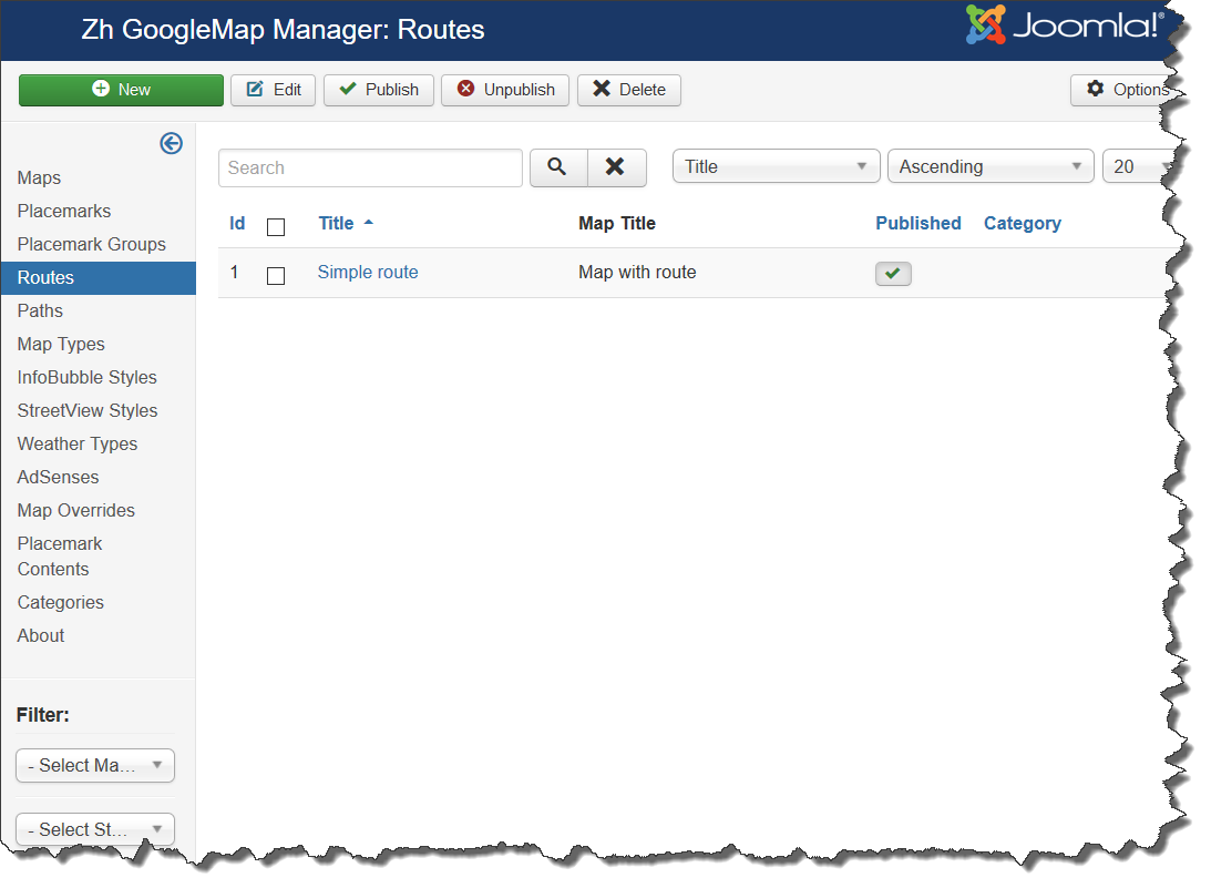
We turn to the tab "Routes".
Enter any number of routes with reference to a specific map.
Field Route - the route is entered for each route point in double quotes ("), the separator between two points is a semicolon (;)
Route Details
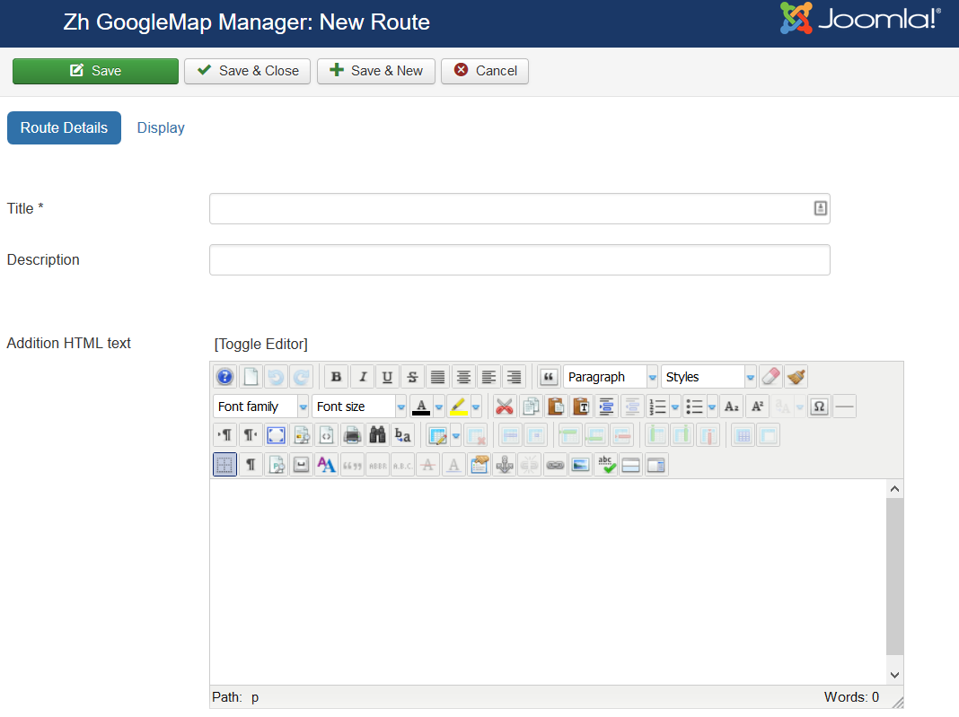
| Title | Route Title |
| Description | Description |
| Addition HTML text | Addition HTML text |
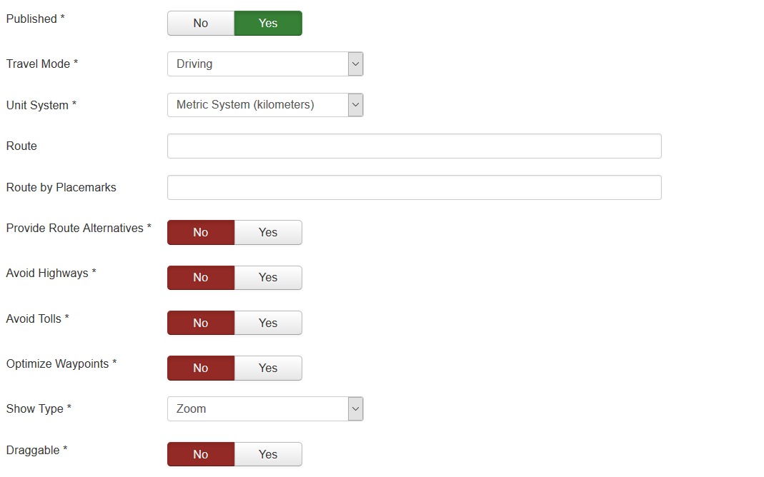
| Published | Published |
| Travel Mode | Travel Mode specifies what mode of transport to use when calculating directions |
| Unit System | The unit system to use when displaying distance |
| Route | Route value - text adderess waypoints in double quotes ("), separator between points is semicolon (;) for example: "Арбатская";"Кропоткинская"; "Москва, проспект Мира 20";"Москва, Петровка 10" |
| Route by Placemarks | Route by placemarks IDs, which separated by semicolon (;) for example: 1;2;4;6 |
| Provide Route Alternatives | Provide Route Alternatives specifies that the Directions service may provide more than one route alternative in the response. |
| Avoid Highways | If true, the routes between origins and destinations will be calculated to avoid highways where possible. |
| Avoid Tolls | If true, the directions between points will be calculated using non-toll routes, if possible. |
| Optimize Waypoints | Optimize Waypoints to allow the Directions service to optimize the provided route by rearranging the waypoints in a more efficient order. |
| Show Type | Map bounds for fitting the route
|
| Draggable | If true, allows the user to drag and modify the paths of routes |
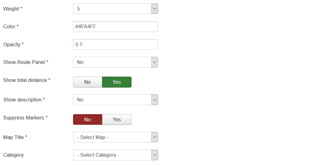
| Weight | Route line weight |
| Color | Route line color |
| Opacity | Route line opacity |
| Show Panel | Allow to show route panel to display the directions steps |
| Show total distance | Show total distance of route |
| Show description | Show description and addition HTML text of route below the map |
| Suppress Markers | Suppress markers, which created for start point, end point, waypoints |
| Map Title | Title of the map, where route would be displayed |
| Category | The category that this route is assigned to |


