Zh GoogleMap SimplePath: Difference between revisions
mNo edit summary |
|||
| (One intermediate revision by the same user not shown) | |||
| Line 1: | Line 1: | ||
== Creating Simple Path == | == Creating Simple Path == | ||
In [[Zh_GoogleMap_ContactPlacemark|previous tutorial]] we created placemark with contact. Now we will create path to our placemark. | |||
'''Path''' is simple polyline between coordinate points. | |||
Go to '''Paths''' tab. | Go to '''Paths''' tab. | ||
| Line 62: | Line 66: | ||
[[File:GM-Tutorial-SimplePath-Paths-ResultZoomed.JPG]] | [[File:GM-Tutorial-SimplePath-Paths-ResultZoomed.JPG]] | ||
=== Create Path by drawing tool === | |||
The new feature - drawing tool | |||
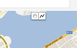
On map there are new controls | |||
[[File:GM-Path-Detail-CreatePolyline-Controls.JPG]] | |||
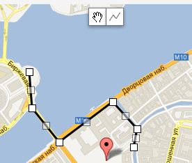
You just simple draw polyline by clicking on points. Double click to stop drawing. | |||
[[File:GM-Path-Detail-CreatePolyline-Polyline.JPG]] | |||
When you finished draw, the '''Current coordinates''' field contain all coordinate values to build path. | |||
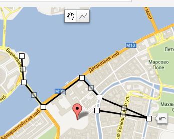
[[File:GM-Path-Detail-CreatePolyline-Polyline-Changed.JPG]] | |||
If you change polyline by draggin its parts, then double click on polyline to get new values in '''Current coordinates''' field (for copy-paste into '''Path''' field) | |||
<p class="zh-text-comment-border"> | |||
The Google's Drawing Library doesn't supports creating polyline with predefined points, therefore component not display path as a polyline for more useful management | |||
</p> | |||
[[Category:Zh GoogleMap|Path]] | [[Category:Zh GoogleMap|Path]] | ||
[[Category:Zh GoogleMap Tutorial|Path]] | [[Category:Zh GoogleMap Tutorial|Path]] | ||
Latest revision as of 18:09, 12 March 2012
Creating Simple Path
In previous tutorial we created placemark with contact. Now we will create path to our placemark.
Path is simple polyline between coordinate points.
Go to Paths tab.
You can see list of your paths.
Press New button to create new path.
You'll see path detail screen and google request to detect your location (to set center of map for you convenience).
Let's create path with default properties for all fields. Only define required fields for new path.
But it is not all that we have to do.
Create Path by Latitude and Longitude
To define path we have to "draw" this path.
First method to do this - fill Path field by pairs of your point coordinates.
To do this:
- set convenient zoom of map
- dragg placemark to your first point (or click on it)
- select coordinates pair from Current coordinates
- copy to clipboard and paste into Path field
- dragg placemark to your next point (or click on it)
- copy current position
- enter ; after first Path value and paste second pair coordinates
- repeat this steps. You'll get Path as pairs of coordidates separated by ; and coordinates (latitude and longitude) separated by ,
- the last pair you can get from placemark, to which you draw the path.
Step 1
Step 2
Step 3
And after that you'll get map like this
and zoom in
Create Path by drawing tool
The new feature - drawing tool
On map there are new controls
You just simple draw polyline by clicking on points. Double click to stop drawing.
When you finished draw, the Current coordinates field contain all coordinate values to build path.
If you change polyline by draggin its parts, then double click on polyline to get new values in Current coordinates field (for copy-paste into Path field)
The Google's Drawing Library doesn't supports creating polyline with predefined points, therefore component not display path as a polyline for more useful management


